Labels

Sunday, July 22, 2012

Janes Island Hike & Canoeing (PQ)

Our second quest today was a hike (more of a walk) and canoeing trip at Jane's Island near Tangier Sound. We did the canoe portion first and immediately decided we wanted to come back and do a longer trip with a kayak --There were so many marshy-offshoots to explore in this area -- it was open, scenic, and beautiful. 

This quest also consisted of two parts -- canoeing and hiking. Both required us to locate a series of numbered signs, each displaying a corresponding letter. After locating all of the signs (11 in all), we were to use the corresponding letters to answer riddles. After answering all of the riddles, we had to solve one final puzzle by unscrambling the corresponding letters to make two words that had to do with this particular quest.

The canoe portion was so peaceful and wonderful! Using our map we navigated a water trail that lead us to each of our 5 clues. Along the way we enjoyed the open space. We saw waterfowl, lots of insects, a blue crab, a small snake & jellyfish. 

Following the canoe portion of the quest, we did the "pedi" portion -- we walked around the park in search of our other clues. Along the way we stumbled across this very large (small melon sized) fungus! Initially I thought it was some kind of coral, but the smell and softness soon proved that it was not.


Below our PQ passport stamp:

And for our memories, the original quest:

Pedi, Paddle Puzzle Trail 

Introduction To Quest
This Quest is designed to introduce you to all that Janes Island State Park has to offer our visitors. The Puzzle Trail has two parts. One part is accomplished on foot (that’s the “Pedi” part), and the other is by boat (that’s the “Paddle” part). Along your way, you will find letters for words missing from the Pedi, Paddle Puzzle Poem (and that’s the “Puzzle” part!). Find all the letters, figure out all the missing words – and learn about the natural environment that makes Janes Island so special and the different ways our visitors can enjoy its resources.
Quest Information
You may begin your Quest on any day of the week between 9 a.m. and 3 p.m. It’s a good idea to visit during the week to avoid waiting for a boat. You will start at the Park Store, where you will obtain your Quest instructions. You can start with either the water portion of the trail or the land portion. For the paddle part, you may bring your own kayaks or canoes or use boats provided by the park. Two crafts will be provided to Park Quest teams at no charge; additional craft will be available at our usual rental rate. Please note that you will not be able to reserve canoes or kayaks in advance; they are available to Park Quest participants as well as to our regular visitors on a first-come first-served basis. You will be allowed one hour to complete your paddle and return all borrowed equipment. Please also note that we will not rent canoes or kayaks if there is lightning in the area or if the wind is blowing 10 miles per hour or more. An alternative Quest will be available when our rental boats are not available because of adverse or hazardous weather conditions.
Because there may be biting insects, remember to bring insect repellant. A long sleeved cotton shirt helps protect you from the bugs and also from the rays of the sun. You will also want to bring bottled water, sunscreen, and sunglasses. Janes Island offers many beautiful vistas and other unique photographic opportunities, so bring your camera, but make sure to carry it in a waterproof bag. Pets that are accustomed to paddling are welcome to join you on the paddle portion of your Quest, as well as all of the land portion. Don’t forget to return to the Park Store by 5 p.m. with your completed Pedi, Paddle Puzzle Poem and get your Passport stamped!
Park Information
Native Americans first settled this region approximately 13,000 years ago. At that time, sea levels were about 200 feet lower than today, and what is today the Chesapeake Bay was then the ancestral Susquehanna River Valley and its tributary rivers. As the Tangier Sound was transformed from a freshwater river to an estuary rich in shellfish, prehistoric cultures occupied the landmass that would become Janes Island. Artifacts found along the shoreline of Janes Island provide evidence of thousands of years of human activities on or near the Island, from hunting mammals to shucking oysters. In a sense, native people living on Janes Island were practicing a lifestyle very similar to the modern watermen surviving off the bounty of the Chesapeake Bay. More recently, the higher portions of the Island were used for farming, and a large fish processing factory was located on the Island’s southern point. Today there are almost no visible traces of the people who lived and worked for so many years on the Island, and it is home only to the many birds, fish, crabs, and other small animals that live and feed in its rich salt marsh.
Today Janes Island State Park includes all of Janes Island and 301 acres on the mainland. The island portion of the park is undeveloped and accessible only by boat. Janes Island is covered in wild and beautiful salt marsh interrupted by hummocks of high ground with scrub vegetation and dissected by numerous guts and channels. The far side of the island features miles of deserted beach on Tangier Sound. Over 30 miles of marked water trails traverse the island, offering ample opportunity for paddlers to explore and experience its wildlife, beauty, and complete tranquility.
The mainland portion of Janes Island State Park features a campground, camping cabins, full service cabins, and a conference center, as well as a marina, picnic areas, playground, ball field, pavilions, Nature Center, and Park Store. Visitors enjoy a variety of activities including paddling, boating, fishing, crabbing, birding or simply watching a breath-taking sunset over the island.


Pocomoke River Hiking and Canoeing (PQ)


Today marked our first family canoeing trip... Well make that two canoeing trips in one day... Pocomoke River was our first, and it was peaceful and wonderful! We did a park quest today that consisted of a short hike followed by a canoe trail on the pocomoke. Both kids, (even our two year old M) did the entire hike on foot this time! No REI hiking carrier on this quest!

The first portion of the quest, the hike, was very short (1 mile), flat, and easy -- During which we had to find a series of pictures along the trail relating to the swamp, the river, and the animals that use it. We learned how to identify tracks of animals native to the area and  important how/why they co-exist and use specific water sources such as ponds, lakes and streams. We had to determine this based on a series of "mystery pictures" that we used to answer the clue questions. The final trail clue ended at the pond, where the kids had the opportunity to use nets to scoop what they could out of the water and take a closer look. Although they tried hard, they were not able to scoop up any fish or tadpoles!

Following the hike we had to complete the second portion of the quest, a 1 mile canoe trail down the Pocomoke River. For us this was the highlight of the trip. We've hiked miles and miles, but this was our (my & the kids... Of course hubby has done all of this before) first canoe trip! We were awed by the slow flowing, glass like water, and found it to be very peaceful and scenic. We did see some waterfowl, birds, and we had the opportunity to see a live painted turtle sunning itself on a log. We also saw large water plants (we have yet to identify). The banks of this river were very marshy and swamp like -- with many small crevices jutting inland between the tall pine trees. Certainly a unique experience for us! The Canoe quest simply required us to draw a picture of the river, and record our feelings & observations as we paddled down the Pocomoke.

I mentioned this before... this was my first canoeing trip (I'm not used to the feel of the paddles)... Anyhow, I thought I was doing a great job paddling at the head of the canoe -- that was until the end of the trip as we were nearing the dock, when my 4 year old, A. finally had enough, and yelled  "Mom! you're splashing me all over"... The entire canoe trip I had been splashing A. as I was making my best attempt to paddle us in the right direction! I'm actually surprised he didn't complain about it sooner... After a few adjustments, I think I finally got the paddling down...  Splashing aside, the kids did wonderfully, and best of all we didn't capsize. They both enjoyed being so close on the water. Of course they sat in the middle of the canoe, and enjoyed the view while D. and I paddled the canoe through the quest!


Below is our PQ Passport stamp.

And for our memories, the original quest below:

 The Mystery of the Great Pocomoke Swamp

Introduction To Quest
Your Park Quest adventure at Pocomoke River State Park will lead you down the river and into a scene straight from prehistoric times as you attempt to discover what is hiding in the swamp. You will travel through areas that appear to be untouched by humankind as you journey along collecting clues to help solve the mystery.
Quest Information
The Park Quest at Pocomoke River State Park will start at the Nature Center located at the Shad Landing Area of Pocomoke River State Park. The nature center will be open and ready to assist park quest teams from Wednesday to Sunday from 9 a.m. until 3 p.m. The Quest may be completed at other times by appointment only, but must be completed by sunset. To request an appointment please call the park at             410-632-2566 begin_of_the_skype_highlighting            410-632-2566      end_of_the_skype_highlighting      . To complete the Quest you will walk approximately one mile and canoe another mile. Quest teams will receive their detective bags in the nature center than use a map located in the bag to proceed down a trail to the boathouse. Along the trail, teams will search for clues as they try to unravel the mystery of the swamp. Upon arrival at the boathouse, teams will be provided with a canoe, lifejackets, paddles, and basic safety instructions before heading towards the river. When the Quest is completed, teams will head back to the nature center to receive their stamp.
Park Quest Worksheet
Park Information
The scenic Pocomoke River is the backdrop for the Shad Landing area of Pocomoke River State Park. Mature stands of bald cypress trees surrounded by their protruding knees form a mysterious, primeval, yet idyllic setting for a paddle through the swamp. Bald eagles, osprey and other birds of prey are often seen nesting in the top of the bald cypress trees. The common prothonotary warbler builds nests in the cavities of decaying cypress knees. Largemouth bass, trout, perch and bluegills swim through the dark water of the Pocomoke River. The forest environment of the swamp provides a rich habitat for a variety of both small and large mammals. Today the swamp is home to a plethora of animal and plant species that find the swamp a useful place to hide and make their homes.
The area around Pocomoke River State Park also boasts of a rich history of human interactions. Records indicate that the Pocomoke, Nanticoke, and Nassawattox tribes inhabited the area more than 10, 000 years ago. In fact, the name Pocomoke is believed to be an Algonquian word meaning “broken” or “pierced” ground. By the mid 1800’s the largely inaccessible swamp had become an important link in the underground railroad used by freedom seeking slaves and their guides. (As well as a number of miscreants, including deserting troops from the north and south, outlaws, and bootleggers!) The state assumed control of the land in the mid 1950’s.

Wednesday, July 18, 2012

North Point State Park Hike (PQ)


I think each new park quest that we complete winds up being my favorite.... This will be a long entry, but I have so much to share because I found it so incredibly interesting! Today, on this heat-index-of-107 degree day, the we chose to partake in a 2.3 hike to complete our Park Quest at North Point State Park (Sans hubby! yes... as I was hiking the trail carrying an extra 30lbs of 2 year old on my back and my 4 year old trailing behind me I was asking myself "am I CRAZY!?").  Don't worry we took extra precautions of using a trackable hiking GPS so hubby knew where we were along our trek, and brought plenty of water & food  along "just in case".We got the hike done by 11am including stopping for a snack break along the trail. I will certainly say, this quest would have been more enjoyable had the heat index been a little lower! Waterfalls of sweat aside, I'm very proud of us! I will say the payoff here was worth it, the history of this place itself was right up my alley -- and we had the opportunity to see a great horned owl in broad daylight.
One of the oldest farming fields in western hemisphere
This state park, yet again, was probably one that we might not have visited if it weren't for Park Quest. Our family tends to gravitate to the more hilly/mountainous trail parks. But, in this quest, it was almost as if we were walking in the footsteps of the thousands of people who used this park from it's earliest inhabitants (9000 years ago, yes NINE THOUSAND!) and up through  its golden years as an amusement park in the 1920's -- this fact made it very intriguing.


We had to follow a series of clue-stops on trails that took us through various parts of the park. Along the trail, we were asked to look at plant life/vegetation and identify certain types of native and invasive plants (sassafras, poison ivy/oak, wineberry etc.). We walked past one of THE OLDEST farm fields in the western hemisphere (photographed left) this field has been continuously farmed since the 1600's!  


The trail here used to be the trolly line, and ahead behind the
fence was the trolly station.
As we continued our hike we learned about the history of the area, which was used in the early 1900's as an amusement park. An eerie feeling when we learned that the narrow hiking trail we were walking on used to be a trolly line that took people from baltimore to the amusement park (left). The area of shrubbery photographed right used to be the bandstand. 


The only reminders that this area now overgrown with vegetation, was once an amusement park are the remaining fountain, the visitors center, and of course the old, unkempt remnants of a sidewalk. It was here at the fountain that we saw a rarity -- a great horned owl, sitting in the center of the fountain in broad daylight. A., did have a question... If owls are nocturnal, why was this one out during the day? We asked the park rangers -- they weren't sure, they thought there was a possibility that he was sick or injured... We hope not! Click photos to enlarge.


The great horned owl in the
center of the historical fountain

This was once a bandstand
imagine this sidewalk when the park
was in use in the early 1900's. Once
connecting parts of the park, now over-
grown with shrubbery and trees.


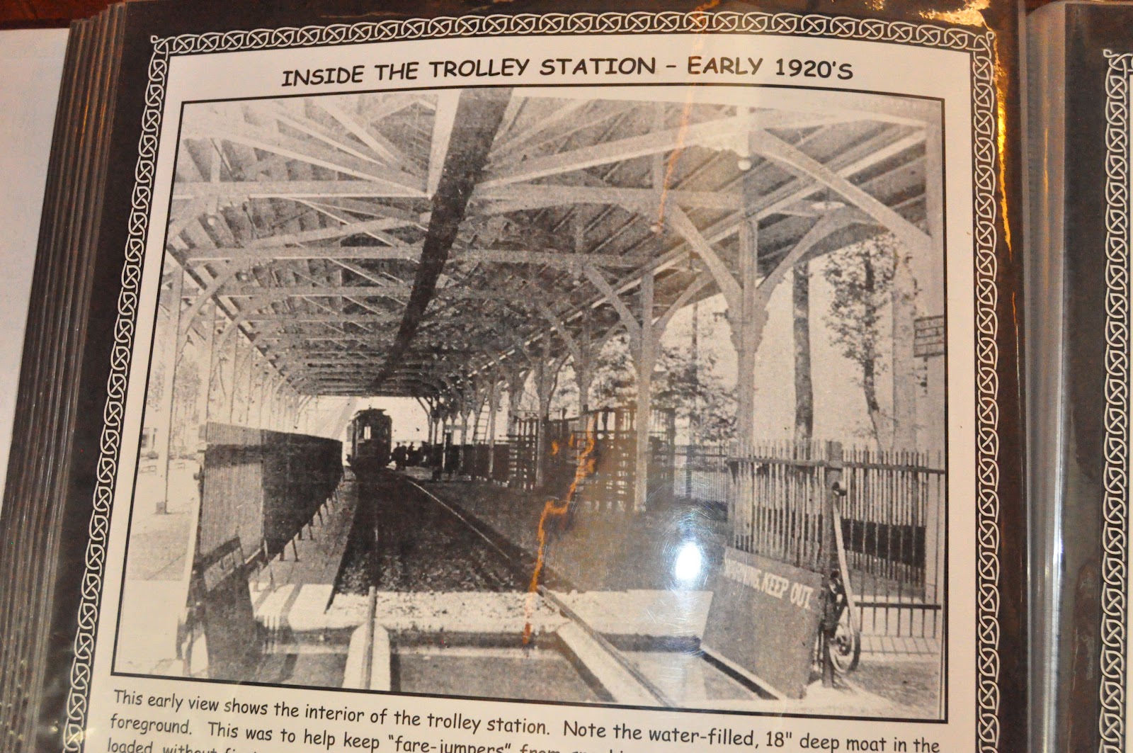
Below, photographs remnants of the sidewalk that used to connect the different parts of the amusement park, and also historical photographs of the fountain, trolley station when it was in use, and parts of the amusement park.
View of area in 1906 -- Notice how few
trees compared to now!


Trolley station when it was in use
View of the fountain & visitors
center
Old advertisements for Bayshore
Park
Our journey through the past continued as we came upon our last stop -- the crystal pier (now in ruins), stretches out 1000 feet into the bay, and was once hustling & bustling with buildings, people, & games.


Crysal Pier Then
View of Crystal Pier today
At the base of the pier looking
 out towards the end of it

Below our PQ Passport stamp


And for our memories, the original Quest description:
Baltimore's Bucolic and Historic Gateway

Introduction To Quest
The North Point State Park Quest will allow participants to explore the history of the North Point peninsula: from the time of European settlement, to the War of 1812, to Bayshore Amusement Park, up to the present-day. Park Quest participants will participate in a scavenger hunt/self-guided tour where they will find traces of Maryland history, as well as learn about the unique role the Chesapeake Bay plays in our environment.
Quest Information
North Point State Park welcomes Park Quest participants daily from 11 a.m. to 3 p.m. Quest participants are encouraged to visit Wednesday through Friday in order to see the Takos Visitor Center. When arriving at the park, please notify the gatehouse attendant that your party is participating in Park Quest, so that they can provide your party with instructions. Quest participants are strongly encouraged to visit on weekdays, as the park often fills to capacity on summer weekends. If the park is filled to capacity, you may not be able to complete the Quest.
Quest participants will obtain a scavenger hunt form that will give clues as the whereabouts of several historic sites and natural features. Each site will have a letterbox. These stops will include the trolley station, the Crystal Pier, a water fountain and the site of the former Bayshore restaurant, among others.
Park Information
North Point State Park is located in Baltimore County on the shores of the Chesapeake Bay and is surrounded by beautiful and fascinating natural and historical resources. It consists of 1,310 acres off North Point Road in Edgemere. The Defenders Trail was used during the War of 1812 and passes near the park. North Point was also the site of Bay Shore Amusement Park, a popular destination for summer visitors from 1906 through 1947. Visitors can see the original trolley station and water fountain, which have been restored. North Point is rich in natural beauty. Come see how Mother Nature reclaimed the land where the amusement park once stood. The park has scenic views overlooking the water, a wading beach, a fishing pier and hiking trails that lead you around the park and through protected Wildlands.


Sunday, July 15, 2012

Gambrill State Park Hike (PQ)

Last hike for the weekend was a short and very sweet hike at Gambrill State Park. The hike, a loop beginning at High Knob area along the black trail & then green trail was only about a mile long, relatively easy, but a little rocky. The quest required us to open a series of letterboxes and solve clues. Upon solving the clues correctly, we were able to attain letters to unscramble one final riddle at the end... Who built Gambrill State Park? Now we know!

The quest reiterated the importance of the role that the CCC (Civilian Conservation Corps) has played in the preservation of Maryland State Parks throughout history. The highlight of this hike was by far the two beautiful overlooks that the trails pass by. Middletown Overlook (left), and then South Frederick Overlook. Both wonderful views. We had a peaceful, quiet hike, and saw only 2 other hikers on the route -- a nice change from the two previous hikes in the morning!


Our 2 year old, M. completed about half the hike on foot -- this was after she hiked almost a mile at Gathland earlier in the day. Combined,  this was definitely one of the longer hiking stretches she has accomplished, so we were very happy to see her interested in going further on her own! Both kids enjoyed playing on yet another natural playground near the historical Tea House along the trail.


Below is a photo of our rubbing for the passport -- the secret words have been blocked out so we don't ruin the fun for other questers!


And finally for our memories I have posted the original quest information.


The Gambrill Pursuit


Pardon Our Dust

Please pardon our dust while we complete the Civilian Conservation Corps Monument Plaza. Construction should be completed by the end of August.

Introduction to Quest
Welcome to the mystery of who built Gambrill State Park! With a variety of letterboxing and problem-solving clues, this self-guided activity will lead your team through one of Maryland’s most beautiful and historic parks!
Quest Information
Plan your quest at Gambrill for any day from 8:00 A.M. until 2 hours before sunset. This will allow adequate time to complete the activity. Your quest is self-guided, meaning that you will not need to access park buildings or locate park staff, and it covers about a mile of territory in the High Knob Area of the park. Your first destination location is the High Knob Nature Center. Locate the Gambrill Pursuit Mailbox outside the building to pick up your clue sheet and a park map. Use this important date to open the mailbox: 1933
Read the questions and use your crayon to record your answers in the passport! The Quest uses historical plaques and letterboxing to provide your team with the answers you need! Your goal is to locate the letters that spell out the answer to this question: Who built Gambrill State Park?
Things to bring:
  • A dark-colored crayon
  • Digital Camera
  • Pen/Pencil
  • Water/snacks
  • Walking shoes/boots
Park Information
Gambrill State Park is a beautiful mountain park, located on the ridge of the Catoctin Mountains in Frederick County. Its most popular feature is the 16 miles of trails for hiking, mountain biking, and horseback riding. The park is separated into two areas, the Rock Run area and the High Knob area. From the 1600-foot High Knob, three stone overlooks offer breathtaking views of the Frederick and Middletown Valleys then continue to the northern reaches of the Shenandoah Mountains.

Greenbriar State Park Hike (PQ)


Very near to Gathland lies Greenbriar state park. We've visited and camped at this park previously, although this time we were there to do a Park Quest. The quest consisted of a 2 mile hike around Greenbriar lake, and through the hike we had to follow "big foot", and answer a series of questions relating to the very important Leave No Trace principle. This conceptin hiking was reiterated here after our most recent trek through Patapsco, were our family also learned about the importance of hiking ethics. A. was a key player in this quest, first, because he loves big foot. Second, because his mind is like a sponge at this age -- he loves guessing for answers and learning from them.

Along the hike, while following the big blue footprints, we talked about the importance of leaving only our footprints, taking only pictures away, staying on the trail, litter, and wild animal safety. After finding and following all 7 of big foot's footprints (Corresponding to the 7 principles of leave no trace), we had the opportunity to play on a natural play area where we spotted big foot! A. was a little disappointed that it was not the real big foot...

This weekend at Greenbriar was horrifically populated especially near the beach areas, so the wildlife here was fairly scarce. We had the opportunity to see a turtle sunning itself on a quiet end of the lake. We also saw a variety of small fish and lots of insects. This quest was absolutely kid friendly and very informative and fun!

I was very excited to see a view of Annapolis rock overlook from the lake, a point that we had hiked to on one of our early trips over a portion of the Appalachian Trail last year. The view from the lake was a great change in perspective from the one that we got as we were actually hiking the trail on the mountain. Below is a photograph I took of Annapolis Rock from the lake. Click on the photograph to enlarge. On the mountain in the center, you can see an outcropping of rocks near the top. That's Annapolis Rock, a beautiful overlook that allows you to see the valley for miles and miles. Along those mountains lie the section of Appalachian trail that we hiked last summer!


Below is our PQ passport stamp for Greenbriar

And for our memories, the original park quest:

What Would Bigfoot do?


Introduction To Quest
Your Park Quest at Greenbrier State Park teaches Questers about the importance of Leave No Trace while participating in outdoor activities. After all, Bigfoot has been doing it for years! Along the way, Bigfoot and his friends Pointer, Trek and Track, Flash, Zoom, Pitch, Sparks and Digger will help Questers learn how to enjoy outdoor activities without hurting the resources and bothering wildlife and other people.
Quest Information
What Would Bigfoot Do? may be completed any day of the week, Questers have a choice of three different check-in and check-out points to pick up their Quest packets and get their passports stamped. The camper registration office is open daily from 8 a.m. to 8 p.m. The visitor center is open Monday to Friday 8 a.m. to 3:30 p.m. and weekends 10 a.m. to 4 p.m. The nature center (located at the beach) is open daily noon to 4 p.m. It will take around two hours to complete the entire What Would Bigfoot Do? Quest. The Quest involves an easy hike — less than 1.5 miles around beautiful Greenbrier Lake.
Questers should bring insect repellent, sunscreen, water, a snack, a camera, and wear sturdy footwear. The hike around the lake is stroller-friendly (paved, gravel and grassy surfaces)! Pets are not permitted in the lake area of Greenbrier during summer months. Pets on leashes are permitted in two of our campground loops, but not on the actual Quest route.
IMPORTANT INFORMATION: Greenbrier State Park is an extremely popular park, often filling to capacity on summer weekends and holidays. If you are Questing on a weekend, it is suggested that you make reservations to camp at Greenbrier and use it as a base camp to complete the Greenbrier, Gathland, Gambrill, Western Maryland Rail Trail and Fort Frederick Quests. If you are not camping at Greenbrier, it is suggested that you do this Quest on a weekday. If you do come on a weekend, traffic may be stopped at the front entrance if the park is filled to capacity. If so, present your passport to the ranger at the gate and we will do our best to find a parking spot for you!
Park Information

Greenbrier is a popular park featuring a 42-acre lake with a 1000-foot white sand swimming beach. Lifeguards are on duty daily during the summer. There are 165 wooded campsites, many within walking distance of the lake. Shaded picnic sites are located near the lake and eight miles of trails are open to hikers and mountain bikers. A concessionaire rents boats.


Gathland State Park PQ walk/hike


This weekend Park Quest took us to see three of northern Maryland's wonderful parks, the first of which was Gathland State Park. We learned a nicely sized tidbit about the history of this park through our guided walk through the park. Deemed Gathland State Park, after George Alfred Townsend, a famous war correspondent -- this park was the site of a battle in the civil war as well as the summer home of Mr. Townsend. We had the opportunity to learn about the buildings in which he lived & used while he was there. His intended Tomb is also featured on the site -- although, surprised to find that no one is buried there. Gath rests in Philadelphia!


The section we did (just within the confines of the previous living grounds for Gath) was an easy 3/4 mile walk/hike. M. did the entire thing on foot. Pet friendly, and not crowded. A favorite feature of the park for us was seeing the large arch dedicated to war correspondents, artists and photographers.  Although this park has more strenuous hikes to offer -- D. has hiked the portion of the Appalachian trail that runs through this and several other parks in the area. 


To get our stamp, we had to visit the south mountain creamery -- where fresh milk & dairy products are made & delivered out to the local community. Of course we had the opportunity to taste the delicious, fresh ice cream -- very welcome after a day of hiking!

And below is our actual passport stamp. This one is a funny memory for us -- you'll notice that there are 2 stamps here. The older ranger at our Seneca Creek Park quest insisted on finding the page to stamp Seneca Creek in my passport himself, because they didn't go in alphabetical order.... And, although he insisted on finding the correct page himself -- he accidentally stamped the wrong one... so Gathland has two!


 And below the original park quest for our memory book.

Who is Buried in Gath's Tomb?

Introduction To Quest
During your Park Quest at Gathland State Park, you will explore the grounds of the former estate of George Alfred Townsend (pen name “Gath”), a famous Civil War correspondent and author. The Quest consists of an easy walk around the grounds of Gathland State Park. There is also a Bonus Quest—a short hike through the woods to a historic Appalachian Trail shelter.
Quest Information
To pick up your Quest packet, go to Gathland Hall, the large building on top of the hill. Open the Park Quest mailbox mounted on the railing on the side of the building using the code 9663 (compress the lock hasp and it will pop open after entering the code). Please sign your team in on the clipboard and get a packet (don’t forget to lock the box afterwards—scramble the numbers to ensure it is locked). Teams will then walk around the grounds of Gath’s former estate and look for answers to the questions in the packet. After you answer the questions, you can complete the Bonus Quest, which will take about an hour. (Gathland Hall and Gathland Lodge are museums, which are currently undergoing extensive renovations. When we originally planned the Quest for Gathland, the museums were due to be open in May 2012. However, due to construction delays out of our control, it is likely the museums will not be open during the summer of 2012.)
Families should bring insect repellant to guard against bothersome gnats, and a flashlight on this quest.
After completion of the Quest, you can have your passport stamped at nearby South Mountain Creamery, a dairy farm well known for their quality products and home delivery. You can enjoy fresh ice cream (buy one, get one free with your passport) and explore the farm. You might consider bringing a cooler along to the creamery, as they have lots of locally produced farm-fresh products you can take home with you. You might even be able to sign up for dairy delivery to your house, as their milk trucks go to a large portion of Maryland! Plan your visit to the dairy between 1:30 and 5:30 p.m. so you can see the cows being milked. They also bottle-feed the calves every day at 4 p.m. The address of South Mountain Creamery is:
8305 Bolivar Road
Middletown, MD 21769
Phone:             301-371-8565      , then press 1 for the store
Who is Buried in Gath’s Tomb? may be completed any day of the week from 9 a.m. until 6 p.m. Questers can also visit nearby South Mountain Creamery, which is open 10 a.m. to 6 p.m. Monday through Saturday, and noon to 6 p.m. on Sunday. It will take around two hours to complete the entire Who is Buried in Gath’s Tomb? Quest. Questers should bring insect repellent, sunscreen, water, a snack, a camera, and wear sturdy footwear. Pets on leashes are allowed (but not inside the museums at Gathland).
Park Information
Gathland State Park is the former estate of George Alfred Townsend, a well-known Civil War correspondent and author who was quite a celebrity in his day. Townsend used a pen name of “Gath” and had high quality cigars and other products named after him (much like today’s celebrities endorse products). Gath was researching the Battle of South Mountain that occurred during the Civil War on September 14, 1862 in three gaps along the ridge of the mountain. He fell in love with Cramptons Gap and purchased land for his estate. Gath built the War Correspondents Arch in 1896 to recognize the brave journalists that covered the battles of the Civil War. Besides the arch, there are two buildings and ruins of several other buildings from his estate that are preserved in the park today. The Appalachian Trail runs through the middle of the park.

For information about Gathland State Park, you can call the South Mountain Recreation Area main office at Greenbrier State Park at             (301) 791-4656       (someone will answer this phone on weekdays 8 a.m. to 3:30 p.m. and on weekends from 10 a.m. to 4 p.m.).
The physical address is:
900 Arnoldstown Road
Jefferson, MD 21718